Trail Walking La Clusaz - Col des ARAVIS ... la Croix des Frêtes. - Photo

Col des ARAVIS ... la Croix des Frêtes.

© OpenStreetMap contributors
Length
Length
7.4 km
Max alt
Max alt
1782 m
Uphill gradient
Uphill gradient
350 m
Km-Effort
Km-Effort  
12.1 km
Min alt
Min alt
1485 m
Downhill gradient
Downhill gradient
349 m
Boucle
Boucle
Yes
Creation date :
2023-07-20 07:47:24.651
Updated on :
2023-07-25 06:54:35.077

(0 Reviews)

Walking
Walking
2h14
Difficulty : Difficult

Scan this QR Code to open this trail in the SityTrail application

FREE GPS app for hiking

Logo SityTrail SityTrail

IGN / Geographical institutes

Download SityTrail from the App Store Download SityTrail from Google Play

Logo SityTrail SityTrail World

The world is yours!

Download SityTrail from the App Store Download SityTrail from Google Play Download SityTrail on Huawei AppGallery

About

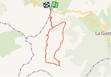
Trail Walking of 7.4 km to be discovered at Auvergne-Rhône-Alpes, Upper Savoy, La Clusaz. This trail is proposed by GerardBouche.

Description

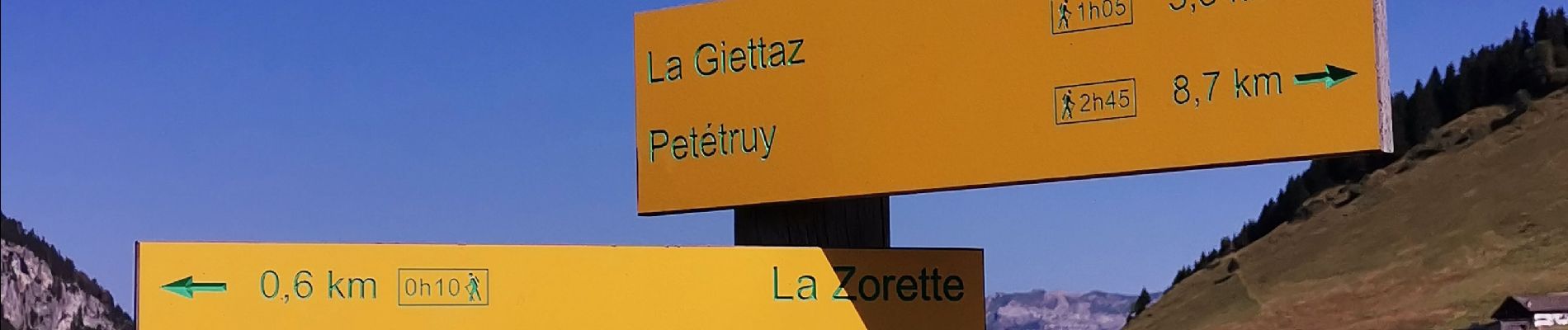
Depuis le col, une montée par le torrent des Aravis jusqu'à la Croix des Frêtes. La descente par l'auberge de Plan Rebord avec une magnifique vue sur le massif Mt-Blanc.

Elevation profile

Photos

Positioning

Country:
France
Region :
Auvergne-Rhône-Alpes
Department/Province :
Upper Savoy
Municipality :
La Clusaz
Location:
Unknown
Start:(UTM)
303192 ; 5082933 (32T) N.

Trails nearby

Trail Snowshoes Manigod - croix de colonban croix de fry - Photo
Snowshoes
myjackotte

Snowshoes

Medium
(3)
Manigod, Auvergne-Rhône-Alpes, Upper Savoy, France
8 km | 11.6 km-effort
3h 5min
Yes
Trail Walking La Giettaz - Le Plan - col de Jaillet - Photo
Walking
wbarge

Walking

Medium
(2)
La Giettaz, Auvergne-Rhône-Alpes, Savoy, France
11.9 km | 19.7 km-effort
4h 18min
Yes
Trail Walking La Clusaz - Les Converses, Le Planet, Beauregard, les Corbassières (boucle) - Photo
Walking
GUIDE
lhomme.ph

Walking

Difficult
La Clusaz, Auvergne-Rhône-Alpes, Upper Savoy, France
10.4 km | 17.7 km-effort
3h 11min
Yes
Trail Snowshoes La Clusaz - col aravis - Photo
Snowshoes
myjackotte

Snowshoes

Easy
(2)
La Clusaz, Auvergne-Rhône-Alpes, Upper Savoy, France
5.7 km | 8.2 km-effort
2h 16min
Yes
Trail Other activity La Giettaz - croise baulet - Photo
Other activity
twistss

Other activity

Very easy
(3)
La Giettaz, Auvergne-Rhône-Alpes, Savoy, France
12.1 km | 27 km-effort
3h 30min
Yes
Trail Mountain bike La Clusaz - VTT Aravis  - Photo
Mountain bike
Tibo74lc

Mountain bike

Medium
(1)
La Clusaz, Auvergne-Rhône-Alpes, Upper Savoy, France
35 km | 52 km-effort
2h 38min
Yes
Trail Mountain bike La Clusaz - Aravis  - Photo
Mountain bike
Tibo74lc

Mountain bike

Very easy
(1)
La Clusaz, Auvergne-Rhône-Alpes, Upper Savoy, France
43 km | 63 km-effort
3h 46min
Yes
Trail Walking Saint-Nicolas-la-Chapelle - SAINT NICOLAS LA CHAPELLE - Photo
Walking
albertville

Walking

Very easy
(1)
Saint-Nicolas-la-Chapelle, Auvergne-Rhône-Alpes, Savoy, France
9.5 km | 16.8 km-effort
3h 41min
No
Trail Motor La Giettaz - La Giettaz - Col des Aravis - Photo
Motor
albertville

Motor

Very easy
(1)
La Giettaz, Auvergne-Rhône-Alpes, Savoy, France
15.8 km | 23 km-effort
58min
No


Close
My subscriptions